


balade le Béage les Lauzières

raab
User
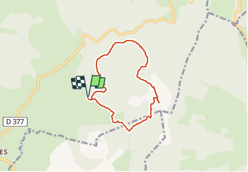

Length
6.3 km

Max alt
1585 m

Uphill gradient
173 m
Km-Effort
8.6 km

Min alt
1433 m

Downhill gradient
173 m
Boucle
Yes
Creation date :
2018-09-03 08:07:17.413
Updated on :
2018-09-03 10:23:26.195
2h15
Difficulty : Very easy

FREE GPS app for hiking
 SityTrail
IGN / Geographical institutes
SityTrail Plus
The world is yours!
About
Trail Walking of 6.3 km to be discovered at Auvergne-Rhône-Alpes, Ardèche, Le Béage. This trail is proposed by raab.
Positioning
Country:
France
Region :
Auvergne-Rhône-Alpes
Department/Province :
Ardèche
Municipality :
Le Béage
Location:
Unknown
Start:(Dec)
Start:(UTM)
591435 ; 4967319 (31T) N.
Comments
Très très belle balade. Parcours varié et nature extraordinaire en cette saison (début juin)